|
|
|||||||||||||||||
| Point ID: 6832 | Downloads | Plots | Site Data | Code: 10420 |
|
|
|||||||||||||||||
| Download | |
|---|---|
| Site Descriptor Information | Site Time Series Data |
| Link to all available data | |
| View: | Time Series | All |
| Units: | mm |
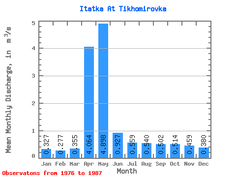
| Statistic | Jan | Feb | Mar | Apr | May | Jun | Jul | Aug | Sep | Oct | Nov | Dec | Annual |
|---|---|---|---|---|---|---|---|---|---|---|---|---|---|
| Mean | 0.33 | 0.28 | 0.35 | 4.06 | 4.90 | 0.93 | 0.56 | 0.54 | 0.50 | 0.51 | 0.46 | 0.38 | 1.14 |
| Standard Deviation | 0.12 | 0.13 | 0.14 | 2.50 | 3.78 | 0.30 | 0.09 | 0.13 | 0.16 | 0.13 | 0.13 | 0.12 | 0.40 |
| Min | 0.08 | 0.00 | 0.17 | 0.52 | 0.97 | 0.57 | 0.43 | 0.37 | 0.34 | 0.38 | 0.29 | 0.25 | 0.61 |
| Max | 0.56 | 0.45 | 0.64 | 8.70 | 14.00 | 1.48 | 0.72 | 0.77 | 0.79 | 0.73 | 0.71 | 0.66 | 1.91 |
| Coefficient of Variation | 0.37 | 0.46 | 0.41 | 0.61 | 0.77 | 0.32 | 0.16 | 0.24 | 0.32 | 0.25 | 0.29 | 0.32 | 0.35 |
 Return to R-Arctic Net Home Page