|
|
|||||||||||||||||
| Point ID: 6832 | Downloads | Plots | Site Data | Code: 10420 |
|
|
|||||||||||||||||
| Download | |
|---|---|
| Site Descriptor Information | Site Time Series Data |
| Link to all available data | |
| View: | Time Series | All |
| Units: | m3/s |
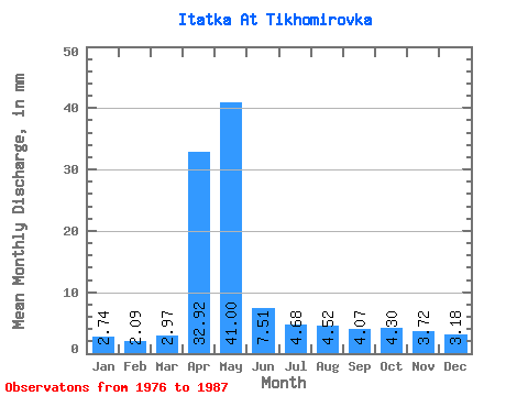
| Statistic | Jan | Feb | Mar | Apr | May | Jun | Jul | Aug | Sep | Oct | Nov | Dec | Annual |
|---|---|---|---|---|---|---|---|---|---|---|---|---|---|
| Mean | 2.74 | 2.11 | 2.98 | 32.92 | 40.99 | 7.51 | 4.68 | 4.52 | 4.07 | 4.30 | 3.72 | 3.18 | 112.55 |
| Standard Deviation | 1.02 | 0.97 | 1.21 | 20.23 | 31.63 | 2.41 | 0.76 | 1.09 | 1.28 | 1.06 | 1.07 | 1.03 | 39.09 |
| Min | 0.65 | 0.02 | 1.42 | 4.21 | 8.12 | 4.62 | 3.60 | 3.10 | 2.75 | 3.18 | 2.35 | 2.09 | 60.41 |
| Max | 4.69 | 3.43 | 5.36 | 70.47 | 117.16 | 11.99 | 6.03 | 6.44 | 6.40 | 6.11 | 5.75 | 5.52 | 188.21 |
| Coefficient of Variation | 0.37 | 0.46 | 0.41 | 0.61 | 0.77 | 0.32 | 0.16 | 0.24 | 0.32 | 0.25 | 0.29 | 0.32 | 0.35 |
 Return to R-Arctic Net Home Page