|
|
|||||||||||||||||
| Point ID: 6831 | Downloads | Plots | Site Data | Code: 10416 |
|
|
|||||||||||||||||
| Download | |
|---|---|
| Site Descriptor Information | Site Time Series Data |
| Link to all available data | |
| View: | Time Series | All |
| Units: | mm |
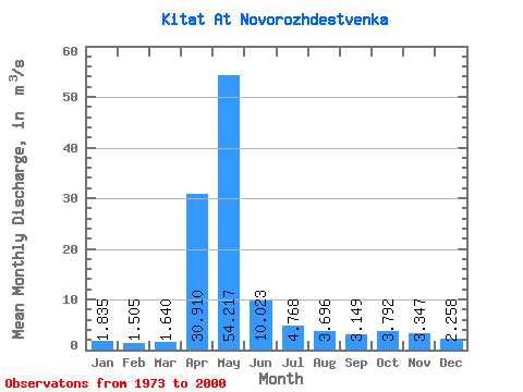
| Statistic | Jan | Feb | Mar | Apr | May | Jun | Jul | Aug | Sep | Oct | Nov | Dec | Annual |
|---|---|---|---|---|---|---|---|---|---|---|---|---|---|
| Mean | 1.83 | 1.50 | 1.64 | 30.91 | 54.22 | 10.02 | 4.77 | 3.70 | 3.15 | 3.79 | 3.35 | 2.26 | 10.10 |
| Standard Deviation | 0.51 | 0.59 | 0.82 | 19.01 | 28.17 | 4.88 | 2.48 | 1.58 | 1.43 | 1.94 | 1.71 | 0.82 | 3.02 |
| Min | 1.25 | 0.99 | 0.65 | 2.54 | 14.70 | 3.48 | 1.22 | 1.05 | 0.85 | 1.26 | 0.93 | 1.03 | 5.54 |
| Max | 3.10 | 3.82 | 4.42 | 68.60 | 114.00 | 20.30 | 10.80 | 6.55 | 6.38 | 9.02 | 6.64 | 3.82 | 15.69 |
| Coefficient of Variation | 0.28 | 0.39 | 0.50 | 0.61 | 0.52 | 0.49 | 0.52 | 0.43 | 0.45 | 0.51 | 0.51 | 0.36 | 0.30 |
 Return to R-Arctic Net Home Page