|
|
|||||||||||||||||
| Point ID: 6831 | Downloads | Plots | Site Data | Code: 10416 |
|
|
|||||||||||||||||
| Download | |
|---|---|
| Site Descriptor Information | Site Time Series Data |
| Link to all available data | |
| View: | Time Series | All |
| Units: | m3/s |
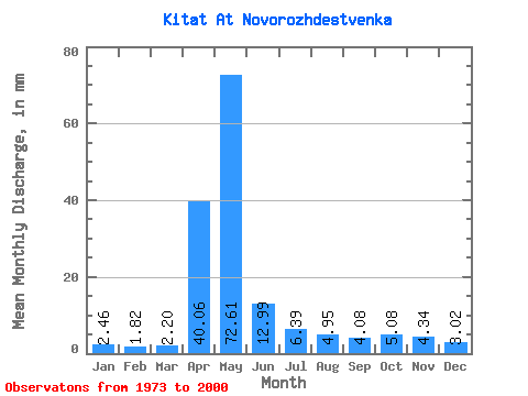
| Statistic | Jan | Feb | Mar | Apr | May | Jun | Jul | Aug | Sep | Oct | Nov | Dec | Annual |
|---|---|---|---|---|---|---|---|---|---|---|---|---|---|
| Mean | 2.46 | 1.84 | 2.20 | 40.06 | 72.60 | 12.99 | 6.38 | 4.95 | 4.08 | 5.08 | 4.34 | 3.02 | 159.30 |
| Standard Deviation | 0.68 | 0.72 | 1.10 | 24.64 | 37.72 | 6.33 | 3.32 | 2.12 | 1.85 | 2.59 | 2.21 | 1.10 | 47.68 |
| Min | 1.67 | 1.21 | 0.87 | 3.29 | 19.68 | 4.51 | 1.63 | 1.41 | 1.10 | 1.69 | 1.21 | 1.38 | 87.36 |
| Max | 4.15 | 4.66 | 5.92 | 88.91 | 152.65 | 26.31 | 14.46 | 8.77 | 8.27 | 12.08 | 8.61 | 5.12 | 247.52 |
| Coefficient of Variation | 0.28 | 0.39 | 0.50 | 0.61 | 0.52 | 0.49 | 0.52 | 0.43 | 0.45 | 0.51 | 0.51 | 0.36 | 0.30 |
 Return to R-Arctic Net Home Page