|
|
|||||||||||||||||
| Point ID: 6830 | Downloads | Plots | Site Data | Code: 10414 |
|
|
|||||||||||||||||
| Download | |
|---|---|
| Site Descriptor Information | Site Time Series Data |
| Link to all available data | |
| View: | Time Series | All |
| Units: | mm |
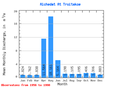
| Statistic | Jan | Feb | Mar | Apr | May | Jun | Jul | Aug | Sep | Oct | Nov | Dec | Annual |
|---|---|---|---|---|---|---|---|---|---|---|---|---|---|
| Mean | 0.82 | 0.76 | 0.84 | 11.56 | 18.16 | 5.16 | 1.20 | 1.10 | 1.09 | 1.41 | 1.31 | 0.88 | 3.68 |
| Standard Deviation | 0.28 | 0.26 | 0.41 | 6.27 | 11.05 | 15.31 | 0.57 | 0.51 | 0.46 | 0.77 | 0.70 | 0.26 | 1.67 |
| Min | 0.36 | 0.26 | 0.37 | 0.29 | 2.82 | 0.81 | 0.56 | 0.48 | 0.44 | 0.42 | 0.43 | 0.39 | 1.97 |
| Max | 1.59 | 1.18 | 2.76 | 29.20 | 38.30 | 95.00 | 3.10 | 2.66 | 2.75 | 4.61 | 4.49 | 1.61 | 11.93 |
| Coefficient of Variation | 0.34 | 0.34 | 0.49 | 0.54 | 0.61 | 2.96 | 0.47 | 0.46 | 0.42 | 0.55 | 0.54 | 0.29 | 0.45 |
 Return to R-Arctic Net Home Page