|
|
|||||||||||||||||
| Point ID: 6830 | Downloads | Plots | Site Data | Code: 10414 |
|
|
|||||||||||||||||
| Download | |
|---|---|
| Site Descriptor Information | Site Time Series Data |
| Link to all available data | |
| View: | Time Series | All |
| Units: | m3/s |
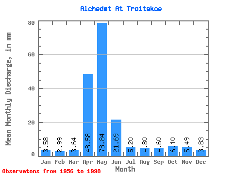
| Statistic | Jan | Feb | Mar | Apr | May | Jun | Jul | Aug | Sep | Oct | Nov | Dec | Annual |
|---|---|---|---|---|---|---|---|---|---|---|---|---|---|
| Mean | 3.58 | 3.01 | 3.64 | 48.58 | 78.83 | 21.69 | 5.20 | 4.80 | 4.60 | 6.10 | 5.48 | 3.83 | 188.06 |
| Standard Deviation | 1.20 | 1.01 | 1.77 | 26.34 | 47.98 | 64.32 | 2.46 | 2.19 | 1.92 | 3.33 | 2.96 | 1.11 | 85.33 |
| Min | 1.56 | 1.03 | 1.61 | 1.22 | 12.24 | 3.40 | 2.43 | 2.08 | 1.85 | 1.82 | 1.81 | 1.69 | 100.64 |
| Max | 6.90 | 4.67 | 11.98 | 122.67 | 166.24 | 399.09 | 13.46 | 11.54 | 11.55 | 20.01 | 18.86 | 6.99 | 610.36 |
| Coefficient of Variation | 0.34 | 0.34 | 0.49 | 0.54 | 0.61 | 2.96 | 0.47 | 0.46 | 0.42 | 0.55 | 0.54 | 0.29 | 0.45 |
 Return to R-Arctic Net Home Page