|
|
|||||||||||||||||
| Point ID: 6829 | Downloads | Plots | Site Data | Code: 10413 |
|
|
|||||||||||||||||
| Download | |
|---|---|
| Site Descriptor Information | Site Time Series Data |
| Link to all available data | |
| View: | Time Series | All |
| Units: | mm |
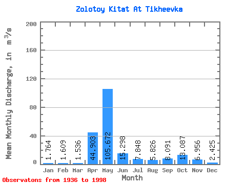
| Statistic | Jan | Feb | Mar | Apr | May | Jun | Jul | Aug | Sep | Oct | Nov | Dec | Annual |
|---|---|---|---|---|---|---|---|---|---|---|---|---|---|
| Mean | 1.76 | 1.61 | 1.54 | 44.90 | 105.67 | 15.30 | 7.85 | 5.83 | 8.09 | 13.09 | 6.96 | 2.42 | 17.92 |
| Standard Deviation | 0.79 | 0.72 | 0.90 | 31.74 | 54.12 | 10.86 | 6.21 | 3.23 | 8.31 | 9.76 | 4.83 | 1.23 | 5.15 |
| Min | 0.54 | 0.48 | 0.30 | 0.79 | 13.80 | 3.24 | 1.77 | 1.39 | 1.34 | 2.05 | 1.02 | 0.65 | 9.41 |
| Max | 4.78 | 4.04 | 4.48 | 115.00 | 266.00 | 48.90 | 23.80 | 13.30 | 50.10 | 42.60 | 23.20 | 6.10 | 38.20 |
| Coefficient of Variation | 0.45 | 0.45 | 0.58 | 0.71 | 0.51 | 0.71 | 0.79 | 0.56 | 1.03 | 0.75 | 0.69 | 0.51 | 0.29 |
 Return to R-Arctic Net Home Page