|
|
|||||||||||||||||
| Point ID: 6829 | Downloads | Plots | Site Data | Code: 10413 |
|
|
|||||||||||||||||
| Download | |
|---|---|
| Site Descriptor Information | Site Time Series Data |
| Link to all available data | |
| View: | Time Series | All |
| Units: | m3/s |
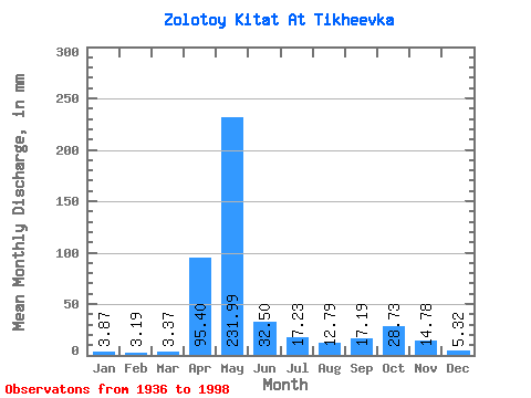
| Statistic | Jan | Feb | Mar | Apr | May | Jun | Jul | Aug | Sep | Oct | Nov | Dec | Annual |
|---|---|---|---|---|---|---|---|---|---|---|---|---|---|
| Mean | 3.87 | 3.22 | 3.37 | 95.40 | 231.96 | 32.50 | 17.23 | 12.79 | 17.19 | 28.73 | 14.78 | 5.32 | 463.51 |
| Standard Deviation | 1.72 | 1.45 | 1.96 | 67.43 | 118.81 | 23.07 | 13.63 | 7.10 | 17.66 | 21.43 | 10.25 | 2.70 | 133.33 |
| Min | 1.19 | 0.96 | 0.66 | 1.68 | 30.29 | 6.88 | 3.88 | 3.05 | 2.85 | 4.50 | 2.17 | 1.43 | 243.53 |
| Max | 10.49 | 8.08 | 9.83 | 244.33 | 583.89 | 103.89 | 52.24 | 29.20 | 106.44 | 93.51 | 49.29 | 13.39 | 988.06 |
| Coefficient of Variation | 0.45 | 0.45 | 0.58 | 0.71 | 0.51 | 0.71 | 0.79 | 0.56 | 1.03 | 0.75 | 0.69 | 0.51 | 0.29 |
 Return to R-Arctic Net Home Page