|
|
|||||||||||||||||
| Point ID: 6825 | Downloads | Plots | Site Data | Code: 10404 |
|
|
|||||||||||||||||
| Download | |
|---|---|
| Site Descriptor Information | Site Time Series Data |
| Link to all available data | |
| View: | Time Series | All |
| Units: | mm |
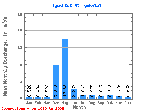
| Statistic | Jan | Feb | Mar | Apr | May | Jun | Jul | Aug | Sep | Oct | Nov | Dec | Annual |
|---|---|---|---|---|---|---|---|---|---|---|---|---|---|
| Mean | 0.53 | 0.48 | 0.52 | 7.85 | 13.88 | 2.34 | 1.06 | 0.97 | 0.82 | 0.91 | 0.78 | 0.63 | 2.55 |
| Standard Deviation | 0.21 | 0.21 | 0.22 | 5.09 | 10.47 | 1.48 | 0.61 | 0.79 | 0.50 | 0.42 | 0.33 | 0.27 | 1.05 |
| Min | 0.17 | 0.19 | 0.23 | 0.67 | 1.53 | 0.79 | 0.45 | 0.35 | 0.36 | 0.43 | 0.35 | 0.29 | 0.95 |
| Max | 0.90 | 0.96 | 1.04 | 20.80 | 43.40 | 6.89 | 3.37 | 3.96 | 2.83 | 2.07 | 1.48 | 1.33 | 4.29 |
| Coefficient of Variation | 0.41 | 0.43 | 0.42 | 0.65 | 0.75 | 0.63 | 0.58 | 0.81 | 0.61 | 0.46 | 0.42 | 0.43 | 0.41 |
 Return to R-Arctic Net Home Page