|
|
|||||||||||||||||
| Point ID: 6825 | Downloads | Plots | Site Data | Code: 10404 |
|
|
|||||||||||||||||
| Download | |
|---|---|
| Site Descriptor Information | Site Time Series Data |
| Link to all available data | |
| View: | Time Series | All |
| Units: | m3/s |
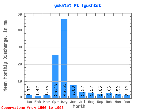
| Statistic | Jan | Feb | Mar | Apr | May | Jun | Jul | Aug | Sep | Oct | Nov | Dec | Annual |
|---|---|---|---|---|---|---|---|---|---|---|---|---|---|
| Mean | 1.77 | 1.48 | 1.75 | 25.49 | 46.59 | 7.60 | 3.57 | 3.27 | 2.65 | 3.06 | 2.52 | 2.12 | 100.84 |
| Standard Deviation | 0.72 | 0.64 | 0.73 | 16.54 | 35.12 | 4.82 | 2.06 | 2.63 | 1.63 | 1.42 | 1.06 | 0.91 | 41.52 |
| Min | 0.57 | 0.58 | 0.77 | 2.18 | 5.13 | 2.57 | 1.51 | 1.18 | 1.17 | 1.44 | 1.14 | 0.97 | 37.70 |
| Max | 3.02 | 2.94 | 3.49 | 67.56 | 145.65 | 22.38 | 11.31 | 13.29 | 9.19 | 6.95 | 4.81 | 4.46 | 169.80 |
| Coefficient of Variation | 0.41 | 0.43 | 0.42 | 0.65 | 0.75 | 0.63 | 0.58 | 0.81 | 0.61 | 0.46 | 0.42 | 0.43 | 0.41 |
 Return to R-Arctic Net Home Page