|
|
|||||||||||||||||
| Point ID: 6820 | Downloads | Plots | Site Data | Code: 10394 |
|
|
|||||||||||||||||
| Download | |
|---|---|
| Site Descriptor Information | Site Time Series Data |
| Link to all available data | |
| View: | Time Series | All |
| Units: | mm |
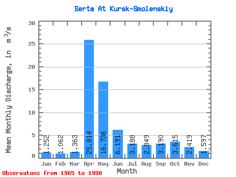
| Statistic | Jan | Feb | Mar | Apr | May | Jun | Jul | Aug | Sep | Oct | Nov | Dec | Annual |
|---|---|---|---|---|---|---|---|---|---|---|---|---|---|
| Mean | 1.25 | 1.06 | 1.36 | 25.81 | 16.74 | 6.19 | 3.19 | 2.85 | 3.19 | 3.62 | 2.42 | 1.60 | 5.74 |
| Standard Deviation | 0.66 | 0.62 | 0.74 | 9.38 | 9.21 | 4.27 | 1.69 | 1.35 | 1.67 | 1.71 | 0.90 | 0.61 | 1.79 |
| Min | 0.42 | 0.37 | 0.42 | 10.00 | 5.52 | 1.65 | 1.00 | 0.76 | 1.31 | 1.67 | 1.10 | 0.82 | 2.85 |
| Max | 3.58 | 3.25 | 3.48 | 52.90 | 39.30 | 20.10 | 8.10 | 6.44 | 7.98 | 8.11 | 4.41 | 3.41 | 9.61 |
| Coefficient of Variation | 0.52 | 0.59 | 0.54 | 0.36 | 0.55 | 0.69 | 0.53 | 0.47 | 0.52 | 0.47 | 0.37 | 0.38 | 0.31 |
 Return to R-Arctic Net Home Page