|
|
|||||||||||||||||
| Point ID: 6820 | Downloads | Plots | Site Data | Code: 10394 |
|
|
|||||||||||||||||
| Download | |
|---|---|
| Site Descriptor Information | Site Time Series Data |
| Link to all available data | |
| View: | Time Series | All |
| Units: | m3/s |
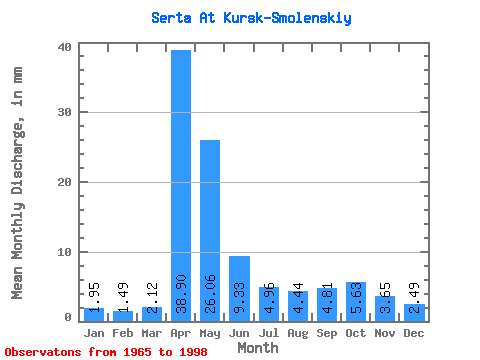
| Statistic | Jan | Feb | Mar | Apr | May | Jun | Jul | Aug | Sep | Oct | Nov | Dec | Annual |
|---|---|---|---|---|---|---|---|---|---|---|---|---|---|
| Mean | 1.95 | 1.51 | 2.12 | 38.90 | 26.06 | 9.33 | 4.96 | 4.44 | 4.81 | 5.63 | 3.65 | 2.49 | 105.37 |
| Standard Deviation | 1.02 | 0.88 | 1.15 | 14.14 | 14.34 | 6.44 | 2.63 | 2.10 | 2.52 | 2.67 | 1.35 | 0.95 | 32.88 |
| Min | 0.65 | 0.53 | 0.65 | 15.07 | 8.60 | 2.49 | 1.56 | 1.18 | 1.97 | 2.60 | 1.66 | 1.28 | 52.37 |
| Max | 5.57 | 4.61 | 5.42 | 79.72 | 61.19 | 30.29 | 12.61 | 10.03 | 12.03 | 12.63 | 6.65 | 5.31 | 176.30 |
| Coefficient of Variation | 0.52 | 0.59 | 0.54 | 0.36 | 0.55 | 0.69 | 0.53 | 0.47 | 0.52 | 0.47 | 0.37 | 0.38 | 0.31 |
 Return to R-Arctic Net Home Page