|
|
|||||||||||||||||
| Point ID: 682 | Downloads | Plots | Site Data | Code: 07BK009 |
|
|
|||||||||||||||||
| Download | |
|---|---|
| Site Descriptor Information | Site Time Series Data |
| Link to all available data | |
| View: | Time Series | All |
| Units: | mm |
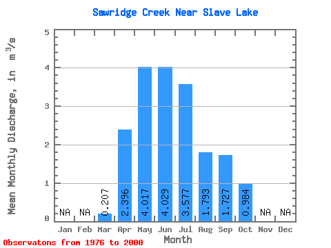
| Statistic | Jan | Feb | Mar | Apr | May | Jun | Jul | Aug | Sep | Oct | Nov | Dec | Annual |
|---|---|---|---|---|---|---|---|---|---|---|---|---|---|
| Mean | 0.21 | 2.40 | 4.02 | 4.03 | 3.58 | 1.79 | 1.73 | 0.98 | |||||
| Standard Deviation | 0.22 | 1.21 | 2.07 | 3.02 | 3.13 | 1.51 | 1.72 | 0.56 | |||||
| Min | 0.01 | 0.66 | 0.82 | 0.86 | 0.37 | 0.13 | 0.19 | 0.21 | |||||
| Max | 1.09 | 4.82 | 9.18 | 14.70 | 10.50 | 5.70 | 7.18 | 2.62 | |||||
| Coefficient of Variation | 1.07 | 0.51 | 0.52 | 0.75 | 0.87 | 0.84 | 1.00 | 0.57 |
 Return to R-Arctic Net Home Page