|
|
|||||||||||||||||
| Point ID: 682 | Downloads | Plots | Site Data | Code: 07BK009 |
|
|
|||||||||||||||||
| Download | |
|---|---|
| Site Descriptor Information | Site Time Series Data |
| Link to all available data | |
| View: | Time Series | All |
| Units: | m3/s |
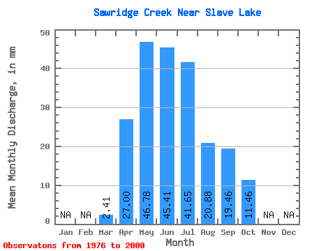
| Statistic | Jan | Feb | Mar | Apr | May | Jun | Jul | Aug | Sep | Oct | Nov | Dec | Annual |
|---|---|---|---|---|---|---|---|---|---|---|---|---|---|
| Mean | 2.37 | 26.65 | 46.16 | 44.82 | 41.11 | 20.60 | 19.21 | 11.31 | |||||
| Standard Deviation | 2.53 | 13.49 | 23.84 | 33.54 | 35.95 | 17.36 | 19.16 | 6.46 | |||||
| Min | 0.08 | 7.35 | 9.47 | 9.58 | 4.23 | 1.49 | 2.16 | 2.40 | |||||
| Max | 12.53 | 53.62 | 105.51 | 163.53 | 120.68 | 65.51 | 79.87 | 30.11 | |||||
| Coefficient of Variation | 1.07 | 0.51 | 0.52 | 0.75 | 0.87 | 0.84 | 1.00 | 0.57 |
 Return to R-Arctic Net Home Page