|
|
|||||||||||||||||
| Point ID: 6816 | Downloads | Plots | Site Data | Code: 10387 |
|
|
|||||||||||||||||
| Download | |
|---|---|
| Site Descriptor Information | Site Time Series Data |
| Link to all available data | |
| View: | Time Series | All |
| Units: | mm |
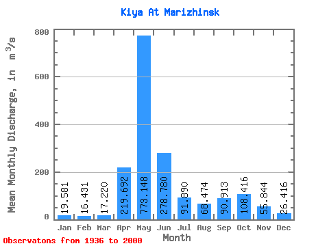
| Statistic | Jan | Feb | Mar | Apr | May | Jun | Jul | Aug | Sep | Oct | Nov | Dec | Annual |
|---|---|---|---|---|---|---|---|---|---|---|---|---|---|
| Mean | 19.58 | 16.43 | 17.22 | 219.69 | 773.15 | 278.78 | 91.89 | 68.47 | 90.91 | 108.42 | 55.84 | 26.42 | 147.23 |
| Standard Deviation | 5.71 | 4.99 | 6.86 | 123.15 | 217.99 | 172.04 | 43.31 | 29.14 | 54.35 | 49.31 | 28.52 | 7.36 | 30.72 |
| Min | 3.01 | 5.64 | 5.41 | 13.00 | 351.00 | 71.40 | 30.30 | 19.20 | 23.10 | 29.20 | 14.60 | 3.08 | 92.13 |
| Max | 37.30 | 34.20 | 54.20 | 560.00 | 1390.00 | 743.00 | 212.00 | 155.00 | 297.00 | 254.00 | 163.00 | 48.60 | 231.91 |
| Coefficient of Variation | 0.29 | 0.30 | 0.40 | 0.56 | 0.28 | 0.62 | 0.47 | 0.43 | 0.60 | 0.46 | 0.51 | 0.28 | 0.21 |
 Return to R-Arctic Net Home Page