|
|
|||||||||||||||||
| Point ID: 6816 | Downloads | Plots | Site Data | Code: 10387 |
|
|
|||||||||||||||||
| Download | |
|---|---|
| Site Descriptor Information | Site Time Series Data |
| Link to all available data | |
| View: | Time Series | All |
| Units: | m3/s |
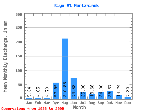
| Statistic | Jan | Feb | Mar | Apr | May | Jun | Jul | Aug | Sep | Oct | Nov | Dec | Annual |
|---|---|---|---|---|---|---|---|---|---|---|---|---|---|
| Mean | 5.34 | 4.08 | 4.70 | 57.99 | 210.84 | 73.58 | 25.06 | 18.67 | 24.00 | 29.57 | 14.74 | 7.20 | 473.19 |
| Standard Deviation | 1.56 | 1.24 | 1.87 | 32.51 | 59.45 | 45.41 | 11.81 | 7.95 | 14.35 | 13.45 | 7.53 | 2.01 | 98.72 |
| Min | 0.82 | 1.40 | 1.48 | 3.43 | 95.72 | 18.85 | 8.26 | 5.24 | 6.10 | 7.96 | 3.85 | 0.84 | 296.10 |
| Max | 10.17 | 8.50 | 14.78 | 147.81 | 379.06 | 196.12 | 57.81 | 42.27 | 78.39 | 69.27 | 43.02 | 13.25 | 745.32 |
| Coefficient of Variation | 0.29 | 0.30 | 0.40 | 0.56 | 0.28 | 0.62 | 0.47 | 0.43 | 0.60 | 0.46 | 0.51 | 0.28 | 0.21 |
 Return to R-Arctic Net Home Page