|
|
|||||||||||||||||
| Point ID: 6815 | Downloads | Plots | Site Data | Code: 10385 |
|
|
|||||||||||||||||
| Download | |
|---|---|
| Site Descriptor Information | Site Time Series Data |
| Link to all available data | |
| View: | Time Series | All |
| Units: | mm |
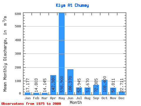
| Statistic | Jan | Feb | Mar | Apr | May | Jun | Jul | Aug | Sep | Oct | Nov | Dec | Annual |
|---|---|---|---|---|---|---|---|---|---|---|---|---|---|
| Mean | 17.18 | 14.80 | 14.14 | 142.38 | 598.90 | 186.37 | 52.95 | 51.67 | 72.39 | 108.40 | 50.81 | 22.71 | 111.89 |
| Standard Deviation | 5.21 | 4.72 | 5.89 | 79.33 | 118.94 | 112.05 | 17.62 | 25.91 | 41.96 | 44.73 | 24.18 | 6.64 | 18.73 |
| Min | 9.14 | 6.67 | 6.39 | 39.80 | 386.00 | 55.00 | 29.80 | 21.20 | 20.70 | 29.30 | 16.90 | 9.40 | 84.64 |
| Max | 27.70 | 24.70 | 29.70 | 303.00 | 827.00 | 531.00 | 95.10 | 135.00 | 154.00 | 176.00 | 130.00 | 34.90 | 150.97 |
| Coefficient of Variation | 0.30 | 0.32 | 0.42 | 0.56 | 0.20 | 0.60 | 0.33 | 0.50 | 0.58 | 0.41 | 0.48 | 0.29 | 0.17 |
 Return to R-Arctic Net Home Page