|
|
|||||||||||||||||
| Point ID: 6815 | Downloads | Plots | Site Data | Code: 10385 |
|
|
|||||||||||||||||
| Download | |
|---|---|
| Site Descriptor Information | Site Time Series Data |
| Link to all available data | |
| View: | Time Series | All |
| Units: | m3/s |
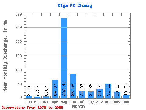
| Statistic | Jan | Feb | Mar | Apr | May | Jun | Jul | Aug | Sep | Oct | Nov | Dec | Annual |
|---|---|---|---|---|---|---|---|---|---|---|---|---|---|
| Mean | 8.10 | 6.36 | 6.67 | 64.97 | 282.37 | 85.05 | 24.96 | 24.36 | 33.03 | 51.11 | 23.19 | 10.71 | 621.67 |
| Standard Deviation | 2.46 | 2.03 | 2.78 | 36.20 | 56.08 | 51.13 | 8.31 | 12.22 | 19.15 | 21.09 | 11.04 | 3.13 | 104.07 |
| Min | 4.31 | 2.87 | 3.01 | 18.16 | 181.99 | 25.10 | 14.05 | 9.99 | 9.45 | 13.81 | 7.71 | 4.43 | 470.29 |
| Max | 13.06 | 10.61 | 14.00 | 138.27 | 389.91 | 242.31 | 44.84 | 63.65 | 70.28 | 82.98 | 59.32 | 16.45 | 838.87 |
| Coefficient of Variation | 0.30 | 0.32 | 0.42 | 0.56 | 0.20 | 0.60 | 0.33 | 0.50 | 0.58 | 0.41 | 0.48 | 0.29 | 0.17 |
 Return to R-Arctic Net Home Page