|
|
|||||||||||||||||
| Point ID: 6798 | Downloads | Plots | Site Data | Code: 10342 |
|
|
|||||||||||||||||
| Download | |
|---|---|
| Site Descriptor Information | Site Time Series Data |
| Link to all available data | |
| View: | Time Series | All |
| Units: | mm |
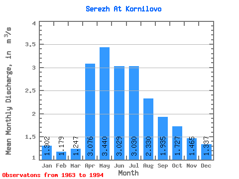
| Statistic | Jan | Feb | Mar | Apr | May | Jun | Jul | Aug | Sep | Oct | Nov | Dec | Annual |
|---|---|---|---|---|---|---|---|---|---|---|---|---|---|
| Mean | 1.30 | 1.18 | 1.25 | 3.08 | 3.44 | 3.03 | 3.03 | 2.33 | 1.94 | 1.73 | 1.47 | 1.34 | 2.08 |
| Standard Deviation | 0.60 | 0.67 | 0.68 | 2.50 | 3.29 | 1.71 | 1.88 | 1.47 | 1.17 | 1.28 | 0.90 | 0.70 | 0.96 |
| Min | 0.07 | 0.06 | 0.02 | 0.27 | 0.36 | 0.71 | 0.88 | 0.64 | 0.37 | 0.47 | 0.27 | 0.10 | 0.78 |
| Max | 3.00 | 2.62 | 2.49 | 9.21 | 15.10 | 6.29 | 8.92 | 6.71 | 4.95 | 7.18 | 5.07 | 3.31 | 4.08 |
| Coefficient of Variation | 0.46 | 0.56 | 0.54 | 0.81 | 0.96 | 0.56 | 0.62 | 0.63 | 0.60 | 0.74 | 0.62 | 0.52 | 0.46 |
 Return to R-Arctic Net Home Page