|
|
|||||||||||||||||
| Point ID: 6798 | Downloads | Plots | Site Data | Code: 10342 |
|
|
|||||||||||||||||
| Download | |
|---|---|
| Site Descriptor Information | Site Time Series Data |
| Link to all available data | |
| View: | Time Series | All |
| Units: | m3/s |
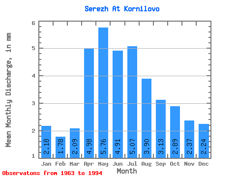
| Statistic | Jan | Feb | Mar | Apr | May | Jun | Jul | Aug | Sep | Oct | Nov | Dec | Annual |
|---|---|---|---|---|---|---|---|---|---|---|---|---|---|
| Mean | 2.18 | 1.80 | 2.09 | 4.98 | 5.76 | 4.91 | 5.07 | 3.90 | 3.13 | 2.89 | 2.37 | 2.24 | 41.06 |
| Standard Deviation | 1.01 | 1.01 | 1.13 | 4.05 | 5.50 | 2.77 | 3.15 | 2.46 | 1.89 | 2.14 | 1.47 | 1.17 | 18.91 |
| Min | 0.11 | 0.09 | 0.04 | 0.44 | 0.60 | 1.15 | 1.47 | 1.07 | 0.60 | 0.79 | 0.44 | 0.17 | 15.37 |
| Max | 5.02 | 4.00 | 4.17 | 14.92 | 25.27 | 10.19 | 14.93 | 11.23 | 8.02 | 12.02 | 8.21 | 5.54 | 80.41 |
| Coefficient of Variation | 0.46 | 0.56 | 0.54 | 0.81 | 0.96 | 0.56 | 0.62 | 0.63 | 0.60 | 0.74 | 0.62 | 0.52 | 0.46 |
 Return to R-Arctic Net Home Page