|
|
|||||||||||||||||
| Point ID: 6797 | Downloads | Plots | Site Data | Code: 10341 |
|
|
|||||||||||||||||
| Download | |
|---|---|
| Site Descriptor Information | Site Time Series Data |
| Link to all available data | |
| View: | Time Series | All |
| Units: | mm |
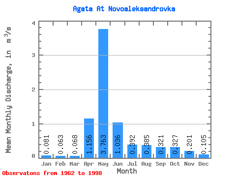
| Statistic | Jan | Feb | Mar | Apr | May | Jun | Jul | Aug | Sep | Oct | Nov | Dec | Annual |
|---|---|---|---|---|---|---|---|---|---|---|---|---|---|
| Mean | 0.08 | 0.06 | 0.07 | 1.16 | 3.76 | 1.04 | 0.39 | 0.39 | 0.32 | 0.33 | 0.20 | 0.10 | 0.66 |
| Standard Deviation | 0.04 | 0.03 | 0.04 | 0.88 | 1.82 | 0.65 | 0.32 | 0.72 | 0.26 | 0.20 | 0.12 | 0.04 | 0.18 |
| Min | 0.04 | 0.03 | 0.02 | 0.08 | 1.05 | 0.16 | 0.14 | 0.05 | 0.09 | 0.09 | 0.07 | 0.04 | 0.36 |
| Max | 0.20 | 0.15 | 0.17 | 3.07 | 9.37 | 3.00 | 1.39 | 4.26 | 1.33 | 0.87 | 0.60 | 0.19 | 1.06 |
| Coefficient of Variation | 0.49 | 0.44 | 0.52 | 0.76 | 0.48 | 0.62 | 0.81 | 1.87 | 0.82 | 0.61 | 0.62 | 0.40 | 0.27 |
 Return to R-Arctic Net Home Page