|
|
|||||||||||||||||
| Point ID: 6797 | Downloads | Plots | Site Data | Code: 10341 |
|
|
|||||||||||||||||
| Download | |
|---|---|
| Site Descriptor Information | Site Time Series Data |
| Link to all available data | |
| View: | Time Series | All |
| Units: | m3/s |
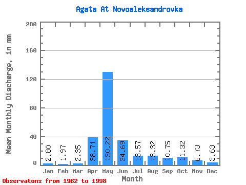
| Statistic | Jan | Feb | Mar | Apr | May | Jun | Jul | Aug | Sep | Oct | Nov | Dec | Annual |
|---|---|---|---|---|---|---|---|---|---|---|---|---|---|
| Mean | 2.81 | 1.98 | 2.34 | 38.72 | 130.21 | 34.69 | 13.57 | 13.32 | 10.74 | 11.32 | 6.75 | 3.63 | 269.28 |
| Standard Deviation | 1.39 | 0.87 | 1.21 | 29.48 | 62.86 | 21.63 | 10.95 | 24.88 | 8.81 | 6.94 | 4.17 | 1.46 | 72.91 |
| Min | 1.25 | 0.91 | 0.80 | 2.65 | 36.33 | 5.36 | 4.84 | 1.87 | 3.08 | 3.04 | 2.21 | 1.52 | 148.29 |
| Max | 6.92 | 4.73 | 5.88 | 102.81 | 324.20 | 100.47 | 48.09 | 147.39 | 44.54 | 30.10 | 20.09 | 6.57 | 431.81 |
| Coefficient of Variation | 0.49 | 0.44 | 0.52 | 0.76 | 0.48 | 0.62 | 0.81 | 1.87 | 0.82 | 0.61 | 0.62 | 0.40 | 0.27 |
 Return to R-Arctic Net Home Page