|
|
|||||||||||||||||
| Point ID: 6791 | Downloads | Plots | Site Data | Code: 10328 |
|
|
|||||||||||||||||
| Download | |
|---|---|
| Site Descriptor Information | Site Time Series Data |
| Link to all available data | |
| View: | Time Series | All |
| Units: | mm |
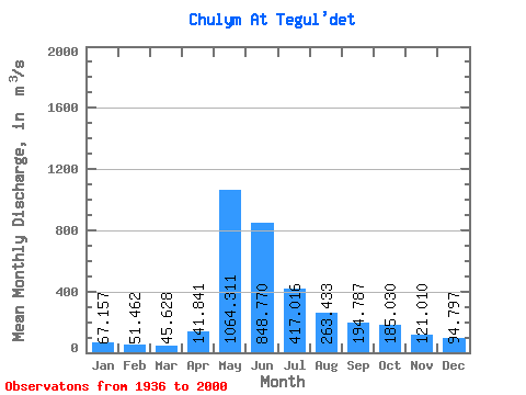
| Statistic | Jan | Feb | Mar | Apr | May | Jun | Jul | Aug | Sep | Oct | Nov | Dec | Annual |
|---|---|---|---|---|---|---|---|---|---|---|---|---|---|
| Mean | 67.16 | 51.46 | 45.63 | 141.84 | 1064.31 | 848.77 | 417.02 | 263.43 | 194.79 | 185.03 | 121.01 | 94.80 | 293.40 |
| Standard Deviation | 18.37 | 12.70 | 10.71 | 97.88 | 208.74 | 272.86 | 162.80 | 122.94 | 55.64 | 61.88 | 42.52 | 31.52 | 51.41 |
| Min | 37.60 | 31.00 | 28.40 | 38.10 | 522.00 | 269.00 | 173.00 | 129.00 | 105.00 | 91.30 | 65.00 | 52.90 | 196.30 |
| Max | 119.00 | 80.70 | 72.50 | 450.00 | 1480.00 | 1600.00 | 840.00 | 760.00 | 380.00 | 332.00 | 260.00 | 197.00 | 396.91 |
| Coefficient of Variation | 0.27 | 0.25 | 0.23 | 0.69 | 0.20 | 0.32 | 0.39 | 0.47 | 0.29 | 0.33 | 0.35 | 0.33 | 0.17 |
 Return to R-Arctic Net Home Page