|
|
|||||||||||||||||
| Point ID: 6791 | Downloads | Plots | Site Data | Code: 10328 |
|
|
|||||||||||||||||
| Download | |
|---|---|
| Site Descriptor Information | Site Time Series Data |
| Link to all available data | |
| View: | Time Series | All |
| Units: | m3/s |
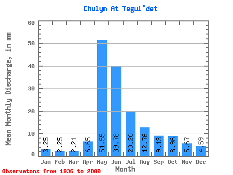
| Statistic | Jan | Feb | Mar | Apr | May | Jun | Jul | Aug | Sep | Oct | Nov | Dec | Annual |
|---|---|---|---|---|---|---|---|---|---|---|---|---|---|
| Mean | 3.25 | 2.27 | 2.21 | 6.65 | 51.54 | 39.78 | 20.20 | 12.76 | 9.13 | 8.96 | 5.67 | 4.59 | 167.44 |
| Standard Deviation | 0.89 | 0.56 | 0.52 | 4.59 | 10.11 | 12.79 | 7.88 | 5.95 | 2.61 | 3.00 | 1.99 | 1.53 | 29.34 |
| Min | 1.82 | 1.37 | 1.38 | 1.79 | 25.28 | 12.61 | 8.38 | 6.25 | 4.92 | 4.42 | 3.05 | 2.56 | 112.03 |
| Max | 5.76 | 3.56 | 3.51 | 21.09 | 71.67 | 75.00 | 40.68 | 36.80 | 17.81 | 16.08 | 12.19 | 9.54 | 226.52 |
| Coefficient of Variation | 0.27 | 0.25 | 0.23 | 0.69 | 0.20 | 0.32 | 0.39 | 0.47 | 0.29 | 0.33 | 0.35 | 0.33 | 0.17 |
 Return to R-Arctic Net Home Page