|
|
|||||||||||||||||
| Point ID: 6788 | Downloads | Plots | Site Data | Code: 10315 |
|
|
|||||||||||||||||
| Download | |
|---|---|
| Site Descriptor Information | Site Time Series Data |
| Link to all available data | |
| View: | Time Series | All |
| Units: | mm |
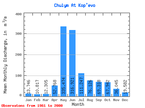
| Statistic | Jan | Feb | Mar | Apr | May | Jun | Jul | Aug | Sep | Oct | Nov | Dec | Annual |
|---|---|---|---|---|---|---|---|---|---|---|---|---|---|
| Mean | 13.75 | 10.82 | 12.30 | 52.77 | 335.47 | 316.92 | 111.25 | 76.13 | 69.32 | 67.94 | 36.05 | 19.58 | 93.48 |
| Standard Deviation | 4.34 | 4.18 | 3.93 | 28.75 | 71.22 | 134.59 | 42.85 | 29.64 | 24.60 | 27.63 | 13.80 | 5.19 | 16.89 |
| Min | 4.64 | 3.46 | 6.38 | 21.60 | 196.00 | 123.00 | 37.70 | 34.80 | 34.70 | 29.00 | 18.40 | 10.20 | 56.84 |
| Max | 22.70 | 21.10 | 24.30 | 160.00 | 493.00 | 642.00 | 285.00 | 193.00 | 122.00 | 167.00 | 83.40 | 32.00 | 121.80 |
| Coefficient of Variation | 0.32 | 0.39 | 0.32 | 0.55 | 0.21 | 0.42 | 0.39 | 0.39 | 0.35 | 0.41 | 0.38 | 0.27 | 0.18 |
 Return to R-Arctic Net Home Page