|
|
|||||||||||||||||
| Point ID: 6788 | Downloads | Plots | Site Data | Code: 10315 |
|
|
|||||||||||||||||
| Download | |
|---|---|
| Site Descriptor Information | Site Time Series Data |
| Link to all available data | |
| View: | Time Series | All |
| Units: | m3/s |
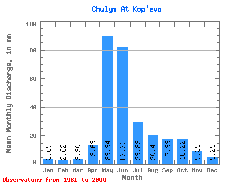
| Statistic | Jan | Feb | Mar | Apr | May | Jun | Jul | Aug | Sep | Oct | Nov | Dec | Annual |
|---|---|---|---|---|---|---|---|---|---|---|---|---|---|
| Mean | 3.69 | 2.64 | 3.30 | 13.69 | 89.93 | 82.23 | 29.82 | 20.41 | 17.98 | 18.21 | 9.35 | 5.25 | 295.33 |
| Standard Deviation | 1.17 | 1.02 | 1.05 | 7.46 | 19.09 | 34.92 | 11.49 | 7.94 | 6.38 | 7.41 | 3.58 | 1.39 | 53.37 |
| Min | 1.24 | 0.84 | 1.71 | 5.60 | 52.54 | 31.91 | 10.11 | 9.33 | 9.00 | 7.77 | 4.77 | 2.73 | 179.55 |
| Max | 6.08 | 5.15 | 6.51 | 41.51 | 132.16 | 166.57 | 76.40 | 51.74 | 31.65 | 44.77 | 21.64 | 8.58 | 384.77 |
| Coefficient of Variation | 0.32 | 0.39 | 0.32 | 0.55 | 0.21 | 0.42 | 0.39 | 0.39 | 0.35 | 0.41 | 0.38 | 0.27 | 0.18 |
 Return to R-Arctic Net Home Page