|
|
|||||||||||||||||
| Point ID: 6783 | Downloads | Plots | Site Data | Code: 10302 |
|
|
|||||||||||||||||
| Download | |
|---|---|
| Site Descriptor Information | Site Time Series Data |
| Link to all available data | |
| View: | Time Series | All |
| Units: | mm |
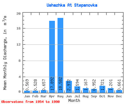
| Statistic | Jan | Feb | Mar | Apr | May | Jun | Jul | Aug | Sep | Oct | Nov | Dec | Annual |
|---|---|---|---|---|---|---|---|---|---|---|---|---|---|
| Mean | 0.57 | 0.53 | 0.66 | 17.89 | 18.58 | 2.97 | 1.59 | 1.17 | 0.95 | 1.72 | 1.20 | 0.66 | 4.26 |
| Standard Deviation | 0.24 | 0.23 | 0.33 | 10.59 | 11.47 | 2.11 | 1.52 | 0.91 | 0.73 | 1.18 | 0.77 | 0.26 | 1.54 |
| Min | 0.16 | 0.24 | 0.25 | 2.04 | 3.33 | 0.64 | 0.20 | 0.33 | 0.20 | 0.42 | 0.38 | 0.26 | 1.56 |
| Max | 1.02 | 0.96 | 1.39 | 36.20 | 45.90 | 8.27 | 6.85 | 3.81 | 2.84 | 4.51 | 3.28 | 1.23 | 6.36 |
| Coefficient of Variation | 0.43 | 0.45 | 0.49 | 0.59 | 0.62 | 0.71 | 0.95 | 0.78 | 0.77 | 0.69 | 0.64 | 0.39 | 0.36 |
 Return to R-Arctic Net Home Page