|
|
|||||||||||||||||
| Point ID: 6783 | Downloads | Plots | Site Data | Code: 10302 |
|
|
|||||||||||||||||
| Download | |
|---|---|
| Site Descriptor Information | Site Time Series Data |
| Link to all available data | |
| View: | Time Series | All |
| Units: | m3/s |
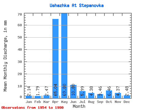
| Statistic | Jan | Feb | Mar | Apr | May | Jun | Jul | Aug | Sep | Oct | Nov | Dec | Annual |
|---|---|---|---|---|---|---|---|---|---|---|---|---|---|
| Mean | 2.14 | 1.81 | 2.47 | 65.04 | 69.79 | 10.80 | 5.99 | 4.38 | 3.46 | 6.46 | 4.37 | 2.48 | 188.54 |
| Standard Deviation | 0.92 | 0.81 | 1.22 | 38.48 | 43.08 | 7.66 | 5.70 | 3.42 | 2.66 | 4.43 | 2.81 | 0.97 | 68.12 |
| Min | 0.60 | 0.82 | 0.94 | 7.42 | 12.51 | 2.33 | 0.75 | 1.24 | 0.73 | 1.58 | 1.38 | 0.98 | 69.20 |
| Max | 3.83 | 3.29 | 5.22 | 131.60 | 172.40 | 30.06 | 25.73 | 14.31 | 10.32 | 16.94 | 11.92 | 4.62 | 281.48 |
| Coefficient of Variation | 0.43 | 0.45 | 0.49 | 0.59 | 0.62 | 0.71 | 0.95 | 0.78 | 0.77 | 0.69 | 0.64 | 0.39 | 0.36 |
 Return to R-Arctic Net Home Page