|
|
|||||||||||||||||
| Point ID: 6781 | Downloads | Plots | Site Data | Code: 10298 |
|
|
|||||||||||||||||
| Download | |
|---|---|
| Site Descriptor Information | Site Time Series Data |
| Link to all available data | |
| View: | Time Series | All |
| Units: | mm |
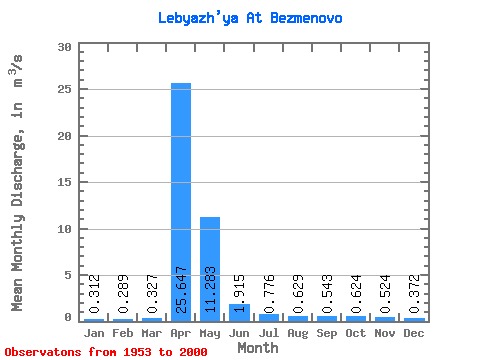
| Statistic | Jan | Feb | Mar | Apr | May | Jun | Jul | Aug | Sep | Oct | Nov | Dec | Annual |
|---|---|---|---|---|---|---|---|---|---|---|---|---|---|
| Mean | 0.31 | 0.29 | 0.33 | 25.65 | 11.28 | 1.92 | 0.78 | 0.63 | 0.54 | 0.62 | 0.52 | 0.37 | 3.63 |
| Standard Deviation | 0.21 | 0.22 | 0.26 | 11.92 | 9.12 | 1.38 | 0.86 | 0.55 | 0.37 | 0.46 | 0.37 | 0.24 | 1.32 |
| Min | 0.04 | 0.04 | 0.04 | 3.19 | 1.21 | 0.33 | 0.10 | 0.08 | 0.07 | 0.06 | 0.08 | 0.05 | 1.33 |
| Max | 0.96 | 0.82 | 1.10 | 56.40 | 42.10 | 6.63 | 5.69 | 3.22 | 2.04 | 2.12 | 1.43 | 1.10 | 6.88 |
| Coefficient of Variation | 0.66 | 0.75 | 0.80 | 0.47 | 0.81 | 0.72 | 1.11 | 0.88 | 0.68 | 0.74 | 0.70 | 0.64 | 0.36 |
 Return to R-Arctic Net Home Page