|
|
|||||||||||||||||
| Point ID: 6781 | Downloads | Plots | Site Data | Code: 10298 |
|
|
|||||||||||||||||
| Download | |
|---|---|
| Site Descriptor Information | Site Time Series Data |
| Link to all available data | |
| View: | Time Series | All |
| Units: | m3/s |
| Statistic | Jan | Feb | Mar | Apr | May | Jun | Jul | Aug | Sep | Oct | Nov | Dec | Annual |
|---|---|---|---|---|---|---|---|---|---|---|---|---|---|
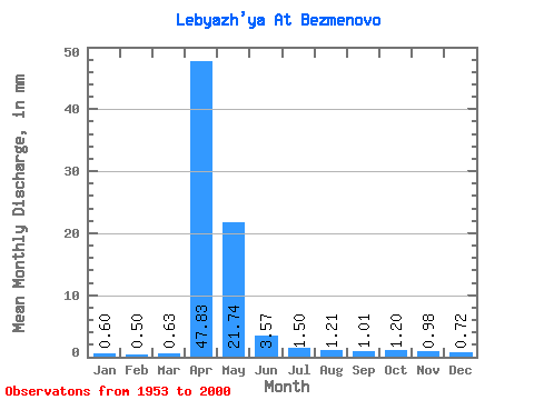
| Mean | 0.60 | 0.51 | 0.63 | 47.83 | 21.74 | 3.57 | 1.50 | 1.21 | 1.01 | 1.20 | 0.98 | 0.72 | 82.46 |
| Standard Deviation | 0.40 | 0.38 | 0.50 | 22.23 | 17.57 | 2.57 | 1.66 | 1.06 | 0.69 | 0.89 | 0.69 | 0.46 | 30.02 |
| Min | 0.08 | 0.08 | 0.08 | 5.95 | 2.33 | 0.61 | 0.18 | 0.16 | 0.12 | 0.11 | 0.15 | 0.10 | 30.29 |
| Max | 1.85 | 1.44 | 2.12 | 105.17 | 81.11 | 12.36 | 10.96 | 6.20 | 3.80 | 4.08 | 2.67 | 2.12 | 156.15 |
| Coefficient of Variation | 0.66 | 0.75 | 0.80 | 0.47 | 0.81 | 0.72 | 1.11 | 0.88 | 0.68 | 0.74 | 0.70 | 0.64 | 0.36 |
 Return to R-Arctic Net Home Page