|
|
|||||||||||||||||
| Point ID: 6759 | Downloads | Plots | Site Data | Code: 10234 |
|
|
|||||||||||||||||
| Download | |
|---|---|
| Site Descriptor Information | Site Time Series Data |
| Link to all available data | |
| View: | Time Series | All |
| Units: | mm |
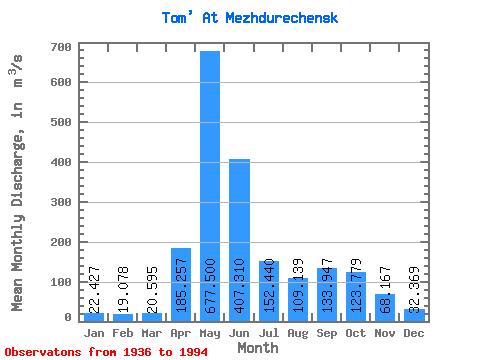
| Statistic | Jan | Feb | Mar | Apr | May | Jun | Jul | Aug | Sep | Oct | Nov | Dec | Annual |
|---|---|---|---|---|---|---|---|---|---|---|---|---|---|
| Mean | 22.43 | 19.08 | 20.59 | 185.26 | 677.50 | 407.31 | 152.44 | 109.14 | 133.95 | 123.78 | 68.17 | 32.37 | 162.62 |
| Standard Deviation | 7.41 | 6.70 | 6.40 | 106.55 | 136.71 | 215.88 | 69.02 | 45.07 | 71.71 | 52.94 | 31.32 | 14.63 | 26.78 |
| Min | 7.75 | 6.68 | 10.10 | 23.40 | 362.00 | 109.00 | 56.90 | 36.90 | 38.20 | 46.30 | 26.40 | 13.60 | 114.36 |
| Max | 38.30 | 39.20 | 34.80 | 509.00 | 1000.00 | 1030.00 | 333.00 | 248.00 | 349.00 | 261.00 | 163.00 | 91.20 | 222.69 |
| Coefficient of Variation | 0.33 | 0.35 | 0.31 | 0.57 | 0.20 | 0.53 | 0.45 | 0.41 | 0.54 | 0.43 | 0.46 | 0.45 | 0.17 |
 Return to R-Arctic Net Home Page