|
|
|||||||||||||||||
| Point ID: 6759 | Downloads | Plots | Site Data | Code: 10234 |
|
|
|||||||||||||||||
| Download | |
|---|---|
| Site Descriptor Information | Site Time Series Data |
| Link to all available data | |
| View: | Time Series | All |
| Units: | m3/s |
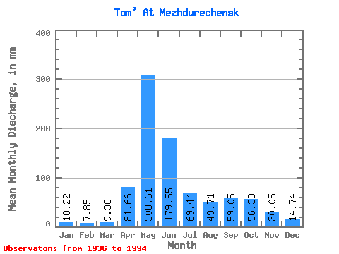
| Statistic | Jan | Feb | Mar | Apr | May | Jun | Jul | Aug | Sep | Oct | Nov | Dec | Annual |
|---|---|---|---|---|---|---|---|---|---|---|---|---|---|
| Mean | 10.21 | 7.92 | 9.38 | 81.66 | 308.56 | 179.55 | 69.43 | 49.71 | 59.05 | 56.37 | 30.05 | 14.74 | 872.87 |
| Standard Deviation | 3.38 | 2.78 | 2.91 | 46.97 | 62.26 | 95.16 | 31.44 | 20.53 | 31.61 | 24.11 | 13.81 | 6.66 | 143.72 |
| Min | 3.53 | 2.77 | 4.60 | 10.31 | 164.87 | 48.05 | 25.91 | 16.81 | 16.84 | 21.09 | 11.64 | 6.19 | 613.80 |
| Max | 17.44 | 16.27 | 15.85 | 224.38 | 455.44 | 454.04 | 151.66 | 112.95 | 153.84 | 118.87 | 71.85 | 41.54 | 1195.26 |
| Coefficient of Variation | 0.33 | 0.35 | 0.31 | 0.57 | 0.20 | 0.53 | 0.45 | 0.41 | 0.54 | 0.43 | 0.46 | 0.45 | 0.17 |
 Return to R-Arctic Net Home Page