|
|
|||||||||||||||||
| Point ID: 6754 | Downloads | Plots | Site Data | Code: 10223 |
|
|
|||||||||||||||||
| Download | |
|---|---|
| Site Descriptor Information | Site Time Series Data |
| Link to all available data | |
| View: | Time Series | All |
| Units: | mm |
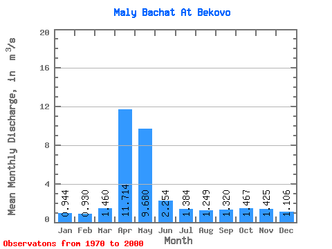
| Statistic | Jan | Feb | Mar | Apr | May | Jun | Jul | Aug | Sep | Oct | Nov | Dec | Annual |
|---|---|---|---|---|---|---|---|---|---|---|---|---|---|
| Mean | 0.94 | 0.93 | 1.46 | 11.71 | 9.68 | 2.25 | 1.38 | 1.25 | 1.32 | 1.47 | 1.43 | 1.11 | 2.91 |
| Standard Deviation | 0.54 | 0.48 | 0.72 | 4.87 | 5.36 | 1.27 | 0.66 | 0.68 | 0.66 | 0.76 | 0.83 | 0.69 | 0.75 |
| Min | 0.21 | 0.30 | 0.58 | 2.23 | 2.24 | 0.50 | 0.42 | 0.46 | 0.42 | 0.41 | 0.44 | 0.34 | 1.34 |
| Max | 2.79 | 2.32 | 3.35 | 24.40 | 23.40 | 6.68 | 3.02 | 3.55 | 2.93 | 3.29 | 3.57 | 2.98 | 4.05 |
| Coefficient of Variation | 0.57 | 0.52 | 0.50 | 0.41 | 0.55 | 0.56 | 0.48 | 0.55 | 0.50 | 0.52 | 0.58 | 0.62 | 0.26 |
 Return to R-Arctic Net Home Page