|
|
|||||||||||||||||
| Point ID: 6754 | Downloads | Plots | Site Data | Code: 10223 |
|
|
|||||||||||||||||
| Download | |
|---|---|
| Site Descriptor Information | Site Time Series Data |
| Link to all available data | |
| View: | Time Series | All |
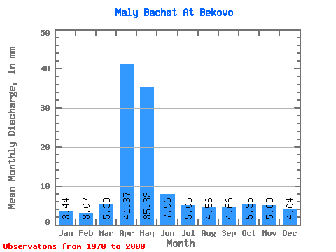
| Units: | m3/s |
| Statistic | Jan | Feb | Mar | Apr | May | Jun | Jul | Aug | Sep | Oct | Nov | Dec | Annual |
|---|---|---|---|---|---|---|---|---|---|---|---|---|---|
| Mean | 3.44 | 3.09 | 5.33 | 41.37 | 35.32 | 7.96 | 5.05 | 4.56 | 4.66 | 5.35 | 5.03 | 4.04 | 125.17 |
| Standard Deviation | 1.98 | 1.60 | 2.65 | 17.18 | 19.54 | 4.48 | 2.41 | 2.48 | 2.34 | 2.78 | 2.92 | 2.51 | 32.31 |
| Min | 0.77 | 1.00 | 2.12 | 7.88 | 8.17 | 1.77 | 1.53 | 1.68 | 1.48 | 1.50 | 1.55 | 1.24 | 57.80 |
| Max | 10.18 | 7.71 | 12.22 | 86.17 | 85.38 | 23.59 | 11.02 | 12.95 | 10.35 | 12.00 | 12.61 | 10.87 | 173.96 |
| Coefficient of Variation | 0.57 | 0.52 | 0.50 | 0.41 | 0.55 | 0.56 | 0.48 | 0.55 | 0.50 | 0.52 | 0.58 | 0.62 | 0.26 |
 Return to R-Arctic Net Home Page