|
|
|||||||||||||||||
| Point ID: 6753 | Downloads | Plots | Site Data | Code: 10221 |
|
|
|||||||||||||||||
| Download | |
|---|---|
| Site Descriptor Information | Site Time Series Data |
| Link to all available data | |
| View: | Time Series | All |
| Units: | mm |
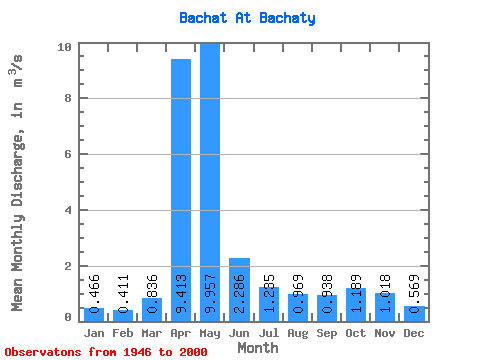
| Statistic | Jan | Feb | Mar | Apr | May | Jun | Jul | Aug | Sep | Oct | Nov | Dec | Annual |
|---|---|---|---|---|---|---|---|---|---|---|---|---|---|
| Mean | 0.47 | 0.41 | 0.84 | 9.41 | 9.96 | 2.29 | 1.23 | 0.97 | 0.94 | 1.19 | 1.02 | 0.57 | 2.44 |
| Standard Deviation | 0.20 | 0.20 | 0.93 | 4.63 | 5.52 | 1.41 | 0.66 | 0.50 | 0.51 | 0.65 | 0.70 | 0.25 | 0.72 |
| Min | 0.13 | 0.09 | 0.11 | 2.08 | 1.51 | 0.50 | 0.39 | 0.31 | 0.22 | 0.19 | 0.22 | 0.12 | 1.20 |
| Max | 0.88 | 0.91 | 6.18 | 21.40 | 23.30 | 5.75 | 3.16 | 2.59 | 2.38 | 2.83 | 4.01 | 1.08 | 4.29 |
| Coefficient of Variation | 0.42 | 0.48 | 1.11 | 0.49 | 0.55 | 0.62 | 0.53 | 0.52 | 0.55 | 0.55 | 0.69 | 0.44 | 0.29 |
 Return to R-Arctic Net Home Page