|
|
|||||||||||||||||
| Point ID: 6753 | Downloads | Plots | Site Data | Code: 10221 |
|
|
|||||||||||||||||
| Download | |
|---|---|
| Site Descriptor Information | Site Time Series Data |
| Link to all available data | |
| View: | Time Series | All |
| Units: | m3/s |
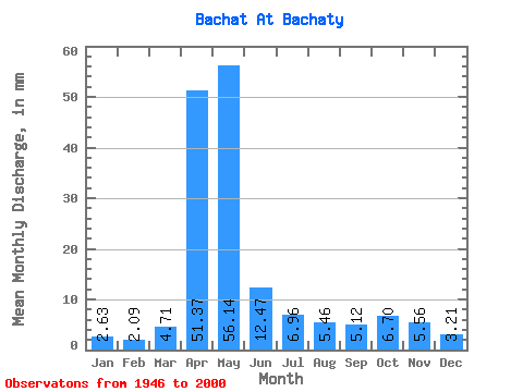
| Statistic | Jan | Feb | Mar | Apr | May | Jun | Jul | Aug | Sep | Oct | Nov | Dec | Annual |
|---|---|---|---|---|---|---|---|---|---|---|---|---|---|
| Mean | 2.63 | 2.11 | 4.71 | 51.37 | 56.14 | 12.47 | 6.96 | 5.46 | 5.12 | 6.70 | 5.56 | 3.21 | 162.27 |
| Standard Deviation | 1.11 | 1.01 | 5.22 | 25.27 | 31.13 | 7.69 | 3.69 | 2.83 | 2.80 | 3.66 | 3.82 | 1.41 | 47.78 |
| Min | 0.73 | 0.47 | 0.62 | 11.35 | 8.51 | 2.73 | 2.20 | 1.75 | 1.20 | 1.07 | 1.20 | 0.68 | 79.90 |
| Max | 4.96 | 4.67 | 34.84 | 116.78 | 131.36 | 31.38 | 17.82 | 14.60 | 12.99 | 15.96 | 21.88 | 6.09 | 284.87 |
| Coefficient of Variation | 0.42 | 0.48 | 1.11 | 0.49 | 0.55 | 0.62 | 0.53 | 0.52 | 0.55 | 0.55 | 0.69 | 0.44 | 0.29 |
 Return to R-Arctic Net Home Page