|
|
|||||||||||||||||
| Point ID: 673 | Downloads | Plots | Site Data | Code: 07BJ003 |
|
|
|||||||||||||||||
| Download | |
|---|---|
| Site Descriptor Information | Site Time Series Data |
| Link to all available data | |
| View: | Time Series | All |
| Units: | mm |
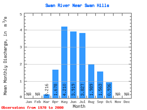
| Statistic | Jan | Feb | Mar | Apr | May | Jun | Jul | Aug | Sep | Oct | Nov | Dec | Annual |
|---|---|---|---|---|---|---|---|---|---|---|---|---|---|
| Mean | 0.22 | 1.68 | 4.21 | 3.92 | 3.83 | 1.99 | 1.56 | 0.94 | |||||
| Standard Deviation | 0.23 | 0.86 | 2.13 | 2.74 | 2.52 | 1.73 | 1.32 | 0.53 | |||||
| Min | 0.04 | 0.31 | 0.93 | 1.07 | 0.63 | 0.39 | 0.24 | 0.34 | |||||
| Max | 1.34 | 3.43 | 7.93 | 15.90 | 10.70 | 7.85 | 5.09 | 2.39 | |||||
| Coefficient of Variation | 1.06 | 0.51 | 0.51 | 0.70 | 0.66 | 0.87 | 0.84 | 0.56 |
 Return to R-Arctic Net Home Page