|
|
|||||||||||||||||
| Point ID: 673 | Downloads | Plots | Site Data | Code: 07BJ003 |
|
|
|||||||||||||||||
| Download | |
|---|---|
| Site Descriptor Information | Site Time Series Data |
| Link to all available data | |
| View: | Time Series | All |
| Units: | m3/s |
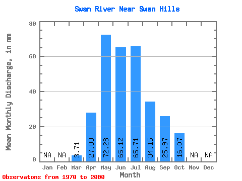
| Statistic | Jan | Feb | Mar | Apr | May | Jun | Jul | Aug | Sep | Oct | Nov | Dec | Annual |
|---|---|---|---|---|---|---|---|---|---|---|---|---|---|
| Mean | 3.70 | 27.89 | 72.27 | 65.11 | 65.69 | 34.15 | 25.98 | 16.07 | |||||
| Standard Deviation | 3.91 | 14.26 | 36.64 | 45.47 | 43.23 | 29.78 | 21.87 | 9.05 | |||||
| Min | 0.70 | 5.17 | 15.90 | 17.78 | 10.76 | 6.66 | 4.04 | 5.92 | |||||
| Max | 23.00 | 56.99 | 136.13 | 264.19 | 183.68 | 134.76 | 84.57 | 41.03 | |||||
| Coefficient of Variation | 1.06 | 0.51 | 0.51 | 0.70 | 0.66 | 0.87 | 0.84 | 0.56 |
 Return to R-Arctic Net Home Page