|
|
|||||||||||||||||
| Point ID: 6696 | Downloads | Plots | Site Data | Code: 10093 |
|
|
|||||||||||||||||
| Download | |
|---|---|
| Site Descriptor Information | Site Time Series Data |
| Link to all available data | |
| View: | Time Series | All |
| Units: | mm |
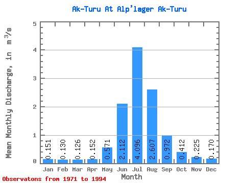
| Statistic | Jan | Feb | Mar | Apr | May | Jun | Jul | Aug | Sep | Oct | Nov | Dec | Annual |
|---|---|---|---|---|---|---|---|---|---|---|---|---|---|
| Mean | 0.15 | 0.13 | 0.13 | 0.15 | 0.57 | 2.11 | 4.10 | 2.61 | 0.97 | 0.41 | 0.23 | 0.17 | 0.91 |
| Standard Deviation | 0.07 | 0.07 | 0.07 | 0.06 | 0.25 | 0.82 | 0.98 | 0.78 | 0.30 | 0.13 | 0.06 | 0.07 | 0.19 |
| Min | 0.01 | 0.01 | 0.02 | 0.04 | 0.24 | 0.68 | 2.43 | 0.92 | 0.40 | 0.28 | 0.16 | 0.08 | 0.63 |
| Max | 0.25 | 0.26 | 0.26 | 0.29 | 1.13 | 3.81 | 5.75 | 4.36 | 1.48 | 0.66 | 0.35 | 0.28 | 1.18 |
| Coefficient of Variation | 0.50 | 0.53 | 0.53 | 0.39 | 0.43 | 0.39 | 0.24 | 0.30 | 0.31 | 0.32 | 0.27 | 0.39 | 0.21 |
 Return to R-Arctic Net Home Page