|
|
|||||||||||||||||
| Point ID: 6696 | Downloads | Plots | Site Data | Code: 10093 |
|
|
|||||||||||||||||
| Download | |
|---|---|
| Site Descriptor Information | Site Time Series Data |
| Link to all available data | |
| View: | Time Series | All |
| Units: | m3/s |
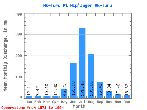
| Statistic | Jan | Feb | Mar | Apr | May | Jun | Jul | Aug | Sep | Oct | Nov | Dec | Annual |
|---|---|---|---|---|---|---|---|---|---|---|---|---|---|
| Mean | 12.10 | 9.46 | 10.09 | 11.76 | 45.76 | 163.89 | 328.45 | 209.02 | 75.42 | 33.01 | 17.46 | 13.63 | 855.86 |
| Standard Deviation | 6.05 | 5.01 | 5.34 | 4.62 | 19.74 | 63.98 | 78.65 | 62.16 | 23.60 | 10.51 | 4.78 | 5.30 | 176.06 |
| Min | 1.12 | 0.58 | 1.36 | 2.79 | 19.24 | 52.77 | 194.84 | 73.77 | 31.04 | 22.45 | 12.42 | 6.50 | 597.34 |
| Max | 20.05 | 18.99 | 20.85 | 22.50 | 90.60 | 295.67 | 461.03 | 349.58 | 114.86 | 52.92 | 27.16 | 22.45 | 1114.68 |
| Coefficient of Variation | 0.50 | 0.53 | 0.53 | 0.39 | 0.43 | 0.39 | 0.24 | 0.30 | 0.31 | 0.32 | 0.27 | 0.39 | 0.21 |
 Return to R-Arctic Net Home Page