|
|
|||||||||||||||||
| Point ID: 6688 | Downloads | Plots | Site Data | Code: 10076 |
|
|
|||||||||||||||||
| Download | |
|---|---|
| Site Descriptor Information | Site Time Series Data |
| Link to all available data | |
| View: | Time Series | All |
| Units: | mm |
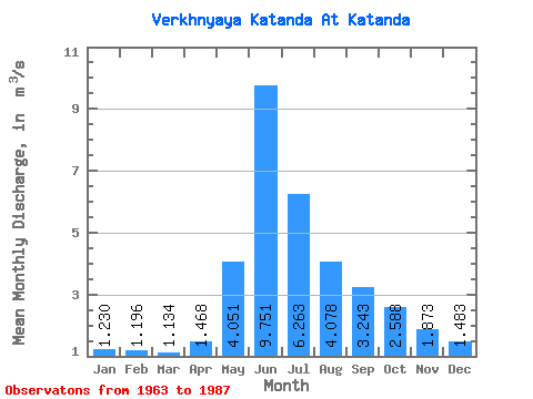
| Statistic | Jan | Feb | Mar | Apr | May | Jun | Jul | Aug | Sep | Oct | Nov | Dec | Annual |
|---|---|---|---|---|---|---|---|---|---|---|---|---|---|
| Mean | 1.23 | 1.20 | 1.13 | 1.47 | 4.05 | 9.75 | 6.26 | 4.08 | 3.24 | 2.59 | 1.87 | 1.48 | 3.21 |
| Standard Deviation | 0.29 | 0.25 | 0.23 | 0.46 | 1.94 | 4.86 | 2.35 | 1.41 | 1.01 | 0.73 | 0.54 | 0.35 | 0.74 |
| Min | 0.71 | 0.77 | 0.83 | 0.83 | 1.03 | 3.90 | 2.46 | 1.82 | 1.62 | 1.40 | 0.88 | 0.94 | 1.99 |
| Max | 1.78 | 1.67 | 1.62 | 2.98 | 9.37 | 23.20 | 11.00 | 7.79 | 5.29 | 4.94 | 2.87 | 2.21 | 4.80 |
| Coefficient of Variation | 0.24 | 0.21 | 0.20 | 0.31 | 0.48 | 0.50 | 0.38 | 0.34 | 0.31 | 0.28 | 0.29 | 0.24 | 0.23 |
 Return to R-Arctic Net Home Page