|
|
|||||||||||||||||
| Point ID: 6688 | Downloads | Plots | Site Data | Code: 10076 |
|
|
|||||||||||||||||
| Download | |
|---|---|
| Site Descriptor Information | Site Time Series Data |
| Link to all available data | |
| View: | Time Series | All |
| Units: | m3/s |
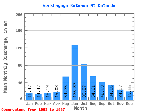
| Statistic | Jan | Feb | Mar | Apr | May | Jun | Jul | Aug | Sep | Oct | Nov | Dec | Annual |
|---|---|---|---|---|---|---|---|---|---|---|---|---|---|
| Mean | 16.48 | 14.59 | 15.18 | 19.02 | 54.24 | 126.37 | 83.86 | 54.61 | 42.03 | 34.65 | 24.27 | 19.86 | 507.22 |
| Standard Deviation | 3.94 | 3.01 | 3.03 | 5.92 | 25.95 | 62.96 | 31.41 | 18.83 | 13.16 | 9.83 | 7.03 | 4.69 | 116.22 |
| Min | 9.51 | 9.39 | 11.11 | 10.76 | 13.79 | 50.54 | 32.94 | 24.37 | 21.00 | 18.75 | 11.40 | 12.59 | 314.02 |
| Max | 23.83 | 20.37 | 21.69 | 38.62 | 125.46 | 300.67 | 147.29 | 104.31 | 68.56 | 66.15 | 37.20 | 29.59 | 758.23 |
| Coefficient of Variation | 0.24 | 0.21 | 0.20 | 0.31 | 0.48 | 0.50 | 0.38 | 0.34 | 0.31 | 0.28 | 0.29 | 0.24 | 0.23 |
 Return to R-Arctic Net Home Page