|
|
|||||||||||||||||
| Point ID: 6665 | Downloads | Plots | Site Data | Code: 10023 |
|
|
|||||||||||||||||
| Download | |
|---|---|
| Site Descriptor Information | Site Time Series Data |
| Link to all available data | |
| View: | Time Series | All |
| Units: | mm |
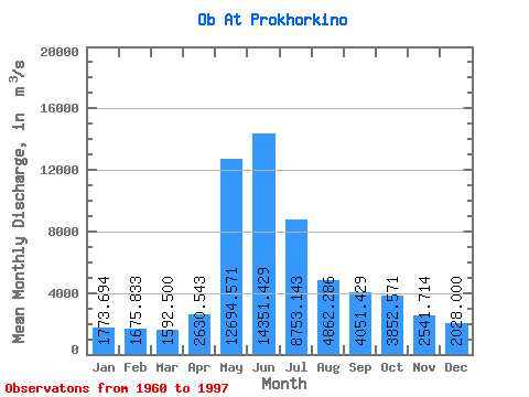
| Statistic | Jan | Feb | Mar | Apr | May | Jun | Jul | Aug | Sep | Oct | Nov | Dec | Annual |
|---|---|---|---|---|---|---|---|---|---|---|---|---|---|
| Mean | 1773.69 | 1675.83 | 1592.50 | 2630.54 | 12694.57 | 14351.43 | 8753.14 | 4862.29 | 4051.43 | 3852.57 | 2541.71 | 2028.00 | 5066.08 |
| Standard Deviation | 232.13 | 253.20 | 232.73 | 782.17 | 2025.38 | 3383.16 | 3476.93 | 1161.41 | 795.21 | 824.75 | 452.03 | 297.17 | 777.04 |
| Min | 1310.00 | 1220.00 | 1100.00 | 1280.00 | 9140.00 | 7730.00 | 3860.00 | 3000.00 | 2700.00 | 2570.00 | 1570.00 | 1500.00 | 3533.33 |
| Max | 2220.00 | 2220.00 | 2080.00 | 4920.00 | 17600.00 | 20900.00 | 15900.00 | 7480.00 | 5950.00 | 5780.00 | 3500.00 | 2660.00 | 6425.83 |
| Coefficient of Variation | 0.13 | 0.15 | 0.15 | 0.30 | 0.16 | 0.24 | 0.40 | 0.24 | 0.20 | 0.21 | 0.18 | 0.15 | 0.15 |
 Return to R-Arctic Net Home Page