|
|
|||||||||||||||||
| Point ID: 6665 | Downloads | Plots | Site Data | Code: 10023 |
|
|
|||||||||||||||||
| Download | |
|---|---|
| Site Descriptor Information | Site Time Series Data |
| Link to all available data | |
| View: | Time Series | All |
| Units: | m3/s |
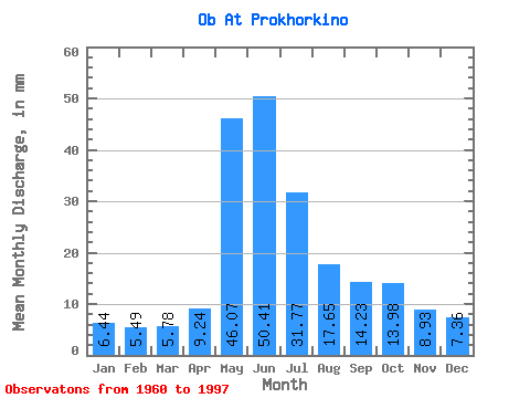
| Statistic | Jan | Feb | Mar | Apr | May | Jun | Jul | Aug | Sep | Oct | Nov | Dec | Annual |
|---|---|---|---|---|---|---|---|---|---|---|---|---|---|
| Mean | 6.44 | 5.54 | 5.78 | 9.24 | 46.06 | 50.41 | 31.76 | 17.64 | 14.23 | 13.98 | 8.93 | 7.36 | 216.65 |
| Standard Deviation | 0.84 | 0.84 | 0.84 | 2.75 | 7.35 | 11.88 | 12.62 | 4.21 | 2.79 | 2.99 | 1.59 | 1.08 | 33.23 |
| Min | 4.75 | 4.03 | 3.99 | 4.50 | 33.17 | 27.15 | 14.01 | 10.89 | 9.48 | 9.33 | 5.51 | 5.44 | 151.10 |
| Max | 8.06 | 7.34 | 7.55 | 17.28 | 63.87 | 73.41 | 57.70 | 27.14 | 20.90 | 20.97 | 12.29 | 9.65 | 274.80 |
| Coefficient of Variation | 0.13 | 0.15 | 0.15 | 0.30 | 0.16 | 0.24 | 0.40 | 0.24 | 0.20 | 0.21 | 0.18 | 0.15 | 0.15 |
 Return to R-Arctic Net Home Page