|
|
|||||||||||||||||
| Point ID: 6663 | Downloads | Plots | Site Data | Code: 10020 |
|
|
|||||||||||||||||
| Download | |
|---|---|
| Site Descriptor Information | Site Time Series Data |
| Link to all available data | |
| View: | Time Series | All |
| Units: | mm |
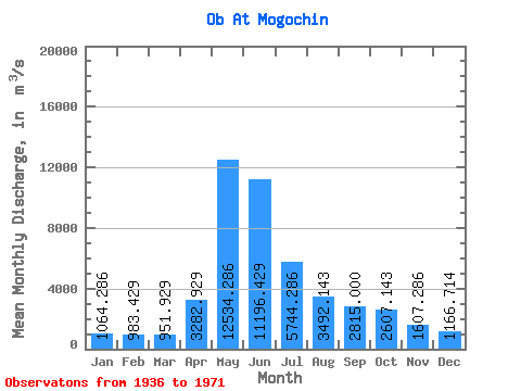
| Statistic | Jan | Feb | Mar | Apr | May | Jun | Jul | Aug | Sep | Oct | Nov | Dec | Annual |
|---|---|---|---|---|---|---|---|---|---|---|---|---|---|
| Mean | 1064.29 | 983.43 | 951.93 | 3282.93 | 12534.29 | 11196.43 | 5744.29 | 3492.14 | 2815.00 | 2607.14 | 1607.29 | 1166.71 | 3953.82 |
| Standard Deviation | 189.13 | 206.01 | 189.72 | 1913.57 | 2934.14 | 4925.71 | 1929.12 | 892.87 | 652.15 | 821.44 | 491.11 | 189.75 | 792.52 |
| Min | 775.00 | 643.00 | 601.00 | 841.00 | 8090.00 | 4500.00 | 2790.00 | 1800.00 | 1970.00 | 1620.00 | 962.00 | 918.00 | 2677.17 |
| Max | 1390.00 | 1460.00 | 1280.00 | 7020.00 | 17800.00 | 19500.00 | 8500.00 | 5590.00 | 4310.00 | 4670.00 | 2780.00 | 1480.00 | 5296.33 |
| Coefficient of Variation | 0.18 | 0.21 | 0.20 | 0.58 | 0.23 | 0.44 | 0.34 | 0.26 | 0.23 | 0.32 | 0.31 | 0.16 | 0.20 |
 Return to R-Arctic Net Home Page