|
|
|||||||||||||||||
| Point ID: 6663 | Downloads | Plots | Site Data | Code: 10020 |
|
|
|||||||||||||||||
| Download | |
|---|---|
| Site Descriptor Information | Site Time Series Data |
| Link to all available data | |
| View: | Time Series | All |
| Units: | m3/s |
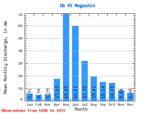
| Statistic | Jan | Feb | Mar | Apr | May | Jun | Jul | Aug | Sep | Oct | Nov | Dec | Annual |
|---|---|---|---|---|---|---|---|---|---|---|---|---|---|
| Mean | 5.91 | 4.98 | 5.29 | 17.65 | 69.64 | 60.21 | 31.91 | 19.40 | 15.14 | 14.48 | 8.64 | 6.48 | 258.88 |
| Standard Deviation | 1.05 | 1.04 | 1.05 | 10.29 | 16.30 | 26.49 | 10.72 | 4.96 | 3.51 | 4.56 | 2.64 | 1.05 | 51.89 |
| Min | 4.31 | 3.25 | 3.34 | 4.52 | 44.95 | 24.20 | 15.50 | 10.00 | 10.59 | 9.00 | 5.17 | 5.10 | 175.29 |
| Max | 7.72 | 7.39 | 7.11 | 37.75 | 98.90 | 104.86 | 47.23 | 31.06 | 23.18 | 25.95 | 14.95 | 8.22 | 346.79 |
| Coefficient of Variation | 0.18 | 0.21 | 0.20 | 0.58 | 0.23 | 0.44 | 0.34 | 0.26 | 0.23 | 0.32 | 0.31 | 0.16 | 0.20 |
 Return to R-Arctic Net Home Page