|
|
|||||||||||||||||
| Point ID: 666 | Downloads | Plots | Site Data | Code: 07BF004 |
|
|
|||||||||||||||||
| Download | |
|---|---|
| Site Descriptor Information | Site Time Series Data |
| Link to all available data | |
| View: | Time Series | All |
| Units: | mm |
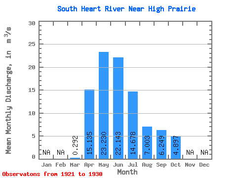
| Statistic | Jan | Feb | Mar | Apr | May | Jun | Jul | Aug | Sep | Oct | Nov | Dec | Annual |
|---|---|---|---|---|---|---|---|---|---|---|---|---|---|
| Mean | 0.29 | 15.13 | 23.23 | 22.14 | 14.68 | 7.00 | 6.25 | 4.90 | |||||
| Standard Deviation | 0.24 | 9.57 | 10.41 | 20.08 | 14.80 | 5.70 | 5.06 | 4.02 | |||||
| Min | 0.03 | 1.39 | 7.90 | 3.34 | 3.22 | 0.78 | 0.84 | 0.54 | |||||
| Max | 0.49 | 31.90 | 41.80 | 68.70 | 52.80 | 18.80 | 13.00 | 11.90 | |||||
| Coefficient of Variation | 0.82 | 0.63 | 0.45 | 0.91 | 1.01 | 0.81 | 0.81 | 0.82 |
 Return to R-Arctic Net Home Page