|
|
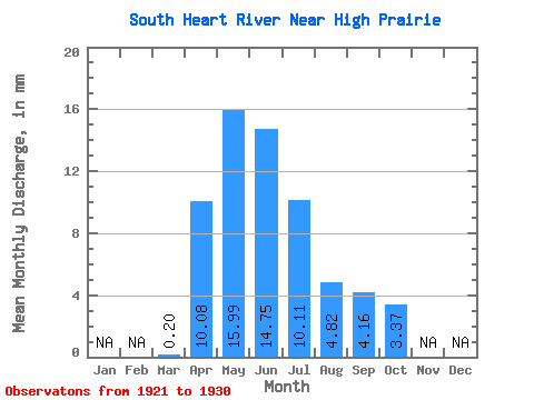
|||||||||||||||||
| Point ID: 666 | Downloads | Plots | Site Data | Code: 07BF004 |
|
|
|||||||||||||||||
| Download | |
|---|---|
| Site Descriptor Information | Site Time Series Data |
| Link to all available data | |
| View: | Time Series | All |
| Units: | m3/s |
| Statistic | Jan | Feb | Mar | Apr | May | Jun | Jul | Aug | Sep | Oct | Nov | Dec | Annual |
|---|---|---|---|---|---|---|---|---|---|---|---|---|---|
| Mean | 0.18 | 9.25 | 14.67 | 13.54 | 9.27 | 4.42 | 3.82 | 3.09 | |||||
| Standard Deviation | 0.15 | 5.85 | 6.57 | 12.27 | 9.35 | 3.60 | 3.09 | 2.54 | |||||
| Min | 0.02 | 0.85 | 4.99 | 2.04 | 2.03 | 0.49 | 0.51 | 0.34 | |||||
| Max | 0.31 | 19.50 | 26.40 | 42.00 | 33.35 | 11.87 | 7.95 | 7.52 | |||||
| Coefficient of Variation | 0.82 | 0.63 | 0.45 | 0.91 | 1.01 | 0.81 | 0.81 | 0.82 |
 Return to R-Arctic Net Home Page