|
|
|||||||||||||||||
| Point ID: 6659 | Downloads | Plots | Site Data | Code: 10010 |
|
|
|||||||||||||||||
| Download | |
|---|---|
| Site Descriptor Information | Site Time Series Data |
| Link to all available data | |
| View: | Time Series | All |
| Units: | mm |
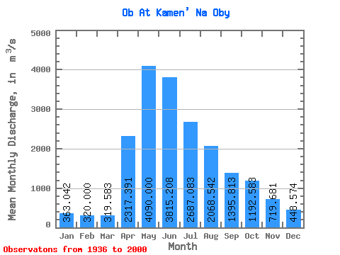
| Statistic | Jan | Feb | Mar | Apr | May | Jun | Jul | Aug | Sep | Oct | Nov | Dec | Annual |
|---|---|---|---|---|---|---|---|---|---|---|---|---|---|
| Mean | 363.04 | 320.00 | 319.58 | 2317.39 | 4090.00 | 3815.21 | 2687.08 | 2068.54 | 1395.81 | 1192.58 | 719.68 | 448.57 | 1647.68 |
| Standard Deviation | 64.49 | 55.61 | 63.21 | 863.23 | 1095.26 | 1092.45 | 920.30 | 1255.78 | 367.55 | 384.55 | 247.24 | 97.62 | 260.94 |
| Min | 234.00 | 202.00 | 201.00 | 506.00 | 2620.00 | 2170.00 | 1420.00 | 1040.00 | 841.00 | 651.00 | 384.00 | 302.00 | 1236.67 |
| Max | 555.00 | 485.00 | 533.00 | 4120.00 | 8400.00 | 7770.00 | 4740.00 | 9690.00 | 2230.00 | 2240.00 | 1340.00 | 731.00 | 2390.75 |
| Coefficient of Variation | 0.18 | 0.17 | 0.20 | 0.37 | 0.27 | 0.29 | 0.34 | 0.61 | 0.26 | 0.32 | 0.34 | 0.22 | 0.16 |
 Return to R-Arctic Net Home Page