|
|
|||||||||||||||||
| Point ID: 6659 | Downloads | Plots | Site Data | Code: 10010 |
|
|
|||||||||||||||||
| Download | |
|---|---|
| Site Descriptor Information | Site Time Series Data |
| Link to all available data | |
| View: | Time Series | All |
| Units: | m3/s |
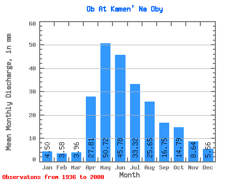
| Statistic | Jan | Feb | Mar | Apr | May | Jun | Jul | Aug | Sep | Oct | Nov | Dec | Annual |
|---|---|---|---|---|---|---|---|---|---|---|---|---|---|
| Mean | 4.50 | 3.62 | 3.96 | 27.81 | 50.71 | 45.78 | 33.31 | 25.65 | 16.75 | 14.79 | 8.64 | 5.56 | 240.75 |
| Standard Deviation | 0.80 | 0.63 | 0.78 | 10.36 | 13.58 | 13.11 | 11.41 | 15.57 | 4.41 | 4.77 | 2.97 | 1.21 | 38.13 |
| Min | 2.90 | 2.28 | 2.49 | 6.07 | 32.48 | 26.04 | 17.61 | 12.89 | 10.09 | 8.07 | 4.61 | 3.74 | 180.69 |
| Max | 6.88 | 5.48 | 6.61 | 49.44 | 104.14 | 93.24 | 58.77 | 120.14 | 26.76 | 27.77 | 16.08 | 9.06 | 349.31 |
| Coefficient of Variation | 0.18 | 0.17 | 0.20 | 0.37 | 0.27 | 0.29 | 0.34 | 0.61 | 0.26 | 0.32 | 0.34 | 0.22 | 0.16 |
 Return to R-Arctic Net Home Page